Walking and Jogging in Provo Canyon Utah
The trail is a paved pathway with no significant hill sections but a fairly constant 2-3% grade. This part of the trail runs between the towering cliffs of the canyon, set off from the highway that runs there as well. In most places there is a generous buffer between the trail and the road, so the impact of highway traffic and noise is minimized. There were a number of small parks strung along the trail that offered parking as well as washroom facilities. Along with the parks there are woods and small fields that if you are lucky as I was, you might see some of the local wildlife. I managed to catch a herd of 10 white tail deer grazing in one of the small meadows during my run up the canyon. There are a number of “unofficial” side trails off into the hills surrounding the trail that would give the runner not only a great hill climbing workout but a number of spectacular views as well.
The Provo Creek trail is used by local walkers, runners, cyclists and in-line skaters year round and is well maintained. I was surprised to see that the asphalt was plowed the day after a small snow storm. A unique feature of the trail is the trail markers painted on the pavement. The local running club (the Orem Sojourners) has accurately measured the distances and painted a series of small triangular markers on the path indicating each quarter mile, for those that want to run intervals or just want to measure a timed distance.
I started the uphill run at a very slow pace, in the late afternoon with the temperature about 38f. The mountains that tower over the canyon where spectacular, and I was in tourist mode. I’m sure that I was weaving all over the trail as I craned my neck back and forth, taking in the scenery, looking for wildlife and runners on the trails above me. Shortly after I made the first turn into the canyon, the warming sun was blocked by the mountain walls surrounding me and the temperature made a definite drop.
The trail was clear and dry for the first two miles but as I ascended further up the canyon the temperature had fell to the freezing mark and the path became icy with snow covered sections. By the time I hit the 3 mile mark the plowed trail had a covering of hard packed snow and it was cold enough to make me slip on my head band to warm my ears. The last mile was through another park area that was not plowed, so I slogged through ankle to foot deep snow on my way to Bridal Veil Falls.
I passed a sign indicating a possible “avalanche hazard” posted on the fence where the final section of trail went. It added a little extra excitement to the run, but as there was little snow so far this year, the actual danger was negligible.
I plowed through the final snow drifts as I arrived at the base of the falls. The alpine cable car here can take you to the top of the mountain spring through fall, but it was now closed for the season. I stopped for a few minutes to take in the sights and rehydrate. There wasn’t a lot of water running over the falls at this time of the year, but it was still spectacular. I didn’t dare stay too long as the trail is not lit, and it would be after dusk before I got back to the parking lot. Besides, it was just too darn cold to be standing around in just my shirt sleeves.
I retraced my steps on the return trip, enjoying the view from the different perspective. As soon as I got back to the plowed section of the trail, I increased my pace, taking advantage of the down hill grade. I slowed on the icy sections fearing a twisted ankle, but picked it up again on the dry sections. A faint but full moon was peeking over the mountain tops as I attempted to catch a runner that appeared through the trees ahead.
The Pipeline Trail Provo Canyon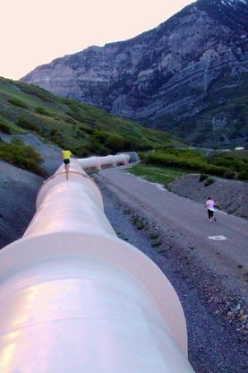
The Pipeline Trail Description
The Pipeline Trail run begins at the mouth of Provo Canyon and heads up the canyon along the Provo River Trail to Canyon Glen. At Canyon Glen, there is a trail up to the Pipeline. Follow the Pipeline towards the mouth of the canyon. Take the road down to the “water fountain” and then rejoin the Provo River Trail. CAUTION: There are cliffs with long drop offs above Canyon Glen – so stay on the trail! DISTANCE: 5 miles. Courtesy of SRCUtah.com Cascade Saddle Trail Provo
|
Provo River Parkway
The Provo River Parkway Trail
The Provo River Parkway System is perhaps one of the finest trail systems anywhere, and one that is always growing and improving. Mt Timpanogos Park Trail
|
Bonneville Trail Provo Utah |
Big Springs Trail Provo Utah |
Realtor in Provo Canyon
|
Search Real Estate in Provo Canyon |